Walk 3: Shopping, Recreation and Housing
The area, now partially rebuilt, originally housed people on low incomes often in rented accommodation and was remarkably self-sufficient in terms of shops and entertainment.
Start in the SPAR car park and make your way on to New Park Road
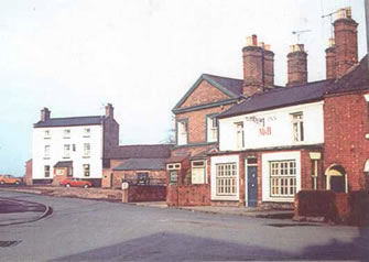
The New Inn and the Post Office with the Canal Tavern to the left
New Park Road was originally much narrower than it is today. The buildings you see in front and either side of you date from the 1970s and were built following widespread demolition of Victorian working class housing. Today many of these would have been saved and upgraded but some really were in an appalling state and there were always tales of ‘ladies of the night’ supplementing meagre incomes.
The Borough Council Conservation Officer Andrew Arroll eventually restricted the developers’ aspirations to rebuild the entire area. Pre-1970 maps show names such as Langford Place (on the site of the Spar car park) and Soho Terrace (where New Park House is now) with Darlow’s General Stores facing on to New Park Road more or less where the entrance to the shopping precinct is now. On the opposite side was Lewis’s Bakery, and next to it from the 1930s to the 1950s was a ‘ballroom’ where dances and dance lessons were held. During the war you could also see films there.

Darlow’s General Stores
… and, turn left and walk up to…
The T-junction at the top of North Street – shops and housing development

Castle Maltings and Canal Tavern c.1963
At the junction of North Street, what was Water Street (now a mere pedestrian access route), and New Park Road (the part leading down to Castle Foregate was always known as Gas House Lane though it is Gasworks Street on early maps) were a number of different shops and pubs over the years. These included the New Inn, the Post Office (one of a number of locations over the years), Steeley’s fish and chip shop, a cobblers and a barber’s shop. A little further round was the Canal Tavern and a road bridge over the canal. Next to the Canal Tavern was a place where coal could be bought and if you paid a few pence a boy would deliver it to your house in a heavy wooden cart. On the site of the Dulux paint shop was a Methodist Chapel that was so popular at one time, it was extended at the rear.
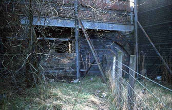
The bridge over the canal on New Park Road/ Gas House Bank just before demolition
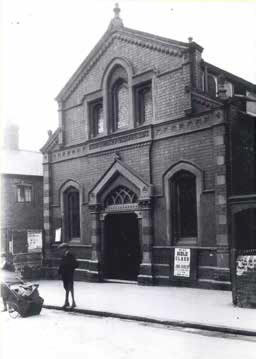
The original Methodist Chapel at the top of New Park Road
Turn down North Street and take the first right into Benyon Street…
On this corner, where there is now a house divided into flats there was a butcher’s shop, which changed hands a number of times but eventually closed in the 1970s.
RECORDING 1
Walk to the end of Benyon Street…
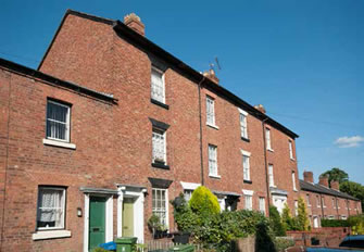
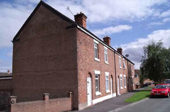
Houses in this street like so many in Castlefields were built in small groups by local builders/developers which give the ‘streetscape’ such variety and interest with lots of different heights and detailing. Through the Shrewsbury Freehold Land Society (founded 1851) local builders and small scale speculators who were members secured individual plots by ballot. Later, with loans from the Shrewsbury Permanent Mutual Benefit Building Society more properties were built. Commonly these were let as flats rather than as a whole house. The houses on Benyon Street were built on the original site of the Benyon’s Flaxmill, hence the name. North Street derived its name as it was to the north of the factory and West Street to the west.
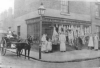
Holl’s butcher’s shop – c1900, North Street/Benyon Street corner
… and turn right into Severn Street…
On your right half way up the street you will see some three storey houses (nos. 5-8a) – these are all that is left of the Benyon’s Flaxmill – probably the warehouse. Later it was used as a weaving workshop (1840s), a meeting place for Wesleyan Reformers (1851) and linen weaving until the 1870s. The construction is iron framed and the slim cruciform iron pillars are still clearly visible inside. New inhabitants have to be warned not to try to remove them!

The footprint of the Benyon’s Flaxmill
5-8a Severn Street – originally the warehouse of the Benyon’s Flaxmill – now private houses
… and to your left is…
The Dog and Pheasant – pubs and houses
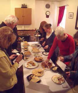
Dog & Pheasant Pie Competition
Castlefields at one time had at least nine pubs and probably several more informal ale houses. In Severn Street alone there was the Dog and Pheasant, the Plough (further up on the left, now no. 45) and, at the top on the right, the Castle. Bass and Worthington were common beers but beers and ales from local breweries like Trouncers and Southams would certainly have been sold as well.
The Dog and Pheasant is a fine example of a ‘community pub’ – one popular charity fundraising event is the annual pie competition.
RECORDING 2
Carry on to the top of Severn Street past Albafont Terrace (built by Mt Whitewell from Belle Vue – NB Alba is Latin for white, font equates to well) and turn right into Beacalls Lane and rejoin New Park Road (formerly Gas House Lane), turn left and go down the road towards Castle Foregate/St. Michael’s Street.
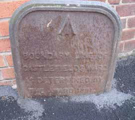
Cast iron boundary marker
On the way down on the left just before a blue gate to Morris’s, look for a cast iron marker in the ground marking the boundary of Castlefields in 1891.
Now turn right up St. Michael’s Street.
The building on the corner to your right (now Nesus and previously Auto Windscreens and next to what was ‘Fitness First’) was once three storeys high and housed the offices of the Shrewsbury Gaslight Company which were adjacent to a substantial gasworks and large gas holders.
St. Michael’s Street was formerly known as Haughmond Street and Old Heath Road, and took its name after the construction of St. Michael’s Church (1829-30).
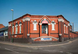
The offices of the Shrewsbury Gaslight Company – originally it had another storey
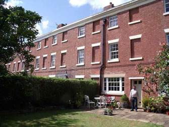
You will pass the elegant but now rather shabby Castle Terrace (104-110 St. Michael’s Street) built in the 1850s by William and Richard Blakeway of the Castle Mills on your right. Further up, opposite Salop Music Centre, you will come to the start of Primrose Terrace, a very neat terrace of houses.
Note the dates over the doorways of nos. 4 and 5 and nos. 28 and 29 which chart their development. Other rows included Simpson’s Square, Akers Houses (after C. Akers – a painter living there in 1882) and Robin Hood Terrace (named after the pub on Crewe Street) – all now gone or redeveloped. A report from an 1853 report states the area was ‘in a disgraceful state… no proper drainage… dirt of privies overflowing the doors…many houses with no back doors’. 38 houses were one-roomed and known as ‘cellar-holes’.
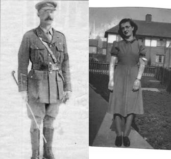
Colonel CRB Wingfield – Mayor of Shrewsbury & Edna Williams of Wingfield Gardens or Close
To your left is the newly refurbished Dolphin Inn (est 1820) and, a little further on, the Flaxmill manager’s house and Ann’s Hill – an early apprentice house for the Flaxmill.
Carry on past the former St. Michael’s Street School (1897) until you come to the Flaxmill-Maltings. Cross the road and go down Marshall’s Court (named after John Marshall, the linen yarn industrialist from Leeds who, with the Benyon brothers built the first iron framed mill).
Bear right down an unsurfaced lane following the wall of the Flaxmill-Maltings until, just before a bridge under the railway, you come to some steps in the wall on your right. Go up the steps along a short path and into Wingfield Close where you turn left and walk down eventually joining Wingfield Gardens. You are now in Ditherington.
John Dalton outside his house in Mount Pleasant Terrace
The Wingfield Gardens estate contained the first council houses erected in Shrewsbury and was built between 1910 and 1914 in a ‘garden city’ style. It (and Wingfield Close) was named after Colonel CRB Wingfield, the Mayor of Shrewsbury at the time who used a charitable society’s gift to purchase nearly 6 acres of land for £800. The 62 houses were designed by Shrewsbury architect AE Williams and built for just over £13,500. The original rents ranged from 3s 6d (17.5p) to 4s 6d (22.5p) per week. ‘They are built in pairs and blocks of three or four around a green lined with alternate lime and London plane trees and are rendered and have prominent gables in steeply sloping chalet type roofs’ (B.Trinder).
Turn right and then left into Whitehouse Gardens. Walk up Whitehouse Gardens until you come to some garages and a turn to the left leading to a bridge over the railway line. Cross the bridge and walk along a short alley before turning right into Bagley Drive. At the junction with Whitemere Road, turn right and walk down until you reach Weston Drive. Turn left up this cul-de-sac and you will reach…
Mount Pleasant – an ambitious investment that never caught on
Gladstone Terrace, Ditherington
This impressive terrace of five houses – originally known as Mount Pleasant and ultimately giving its name to the entire area – was built on the site of the Shropshire Hunt kennels by William Hazeldine (the iron master from Coleham who supplied the iron work for the Flaxmill) in the 1830s. Having bought a sizeable plot of land it was meant to be the ambitious first investment step in creating a ‘posh area’ to the north of Shrewsbury. Unfortunately, it never caught on (Holywell Terrace near the Abbey and eventually Kennedy Road by Shrewsbury School took that mantle) and the terrace stood in stately isolation surrounded by a number of small scale speculator ‘cottages’ which were demolished in the late 1950s to make way for modern ‘estate’ housing.
RECORDING 3
Retrace your steps down Weston Drive and turn left into Whitemere Road and then to the junction with Mount Pleasant Road. Turn right, go under the railway bridge and almost immediately turn right (pedestrian access only) to join Long Row. Follow Long Row, past Gladstone Terrace, the Compasses pub (the name springs from the biblical ‘God Encompasses Us’ – other pubs are known as the Goat and Compasses for the same reason) on your right and Ditherington Community Centre (former infants’ school) on your left. Bear left along a row of terraced houses (formerly Haughmond Terrace and a survivor of widespread 60s and 70s clearances) to join Ditherington Road – there is a bike shop on the corner.
There is a popular belief that Ditherington refers to people ‘dithering’ on their way to the gallows at Old Heath which makes a good story but is almost certainly not true.
Cross Ditherington Road, turn right and walk down as it turns into Spring Gardens until, on the other side of the road, you see…
The Coach pub – the route into/out of Shrewsbury
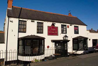
The Coach, formerly known as The Comet
The Coach was originally called the Comet – in its latter days it had a reputation for having a ‘difficult’ clientele with fights and visits from the police being a regular occurrence right up to the 1990s. The change of name was no doubt an attempt to put the past behind it.
RECORDING 4
The Comet took its name from a stage coach company that probably had runs to Birmingham and London. The pub is seemingly set below the road with
steps down to it. In reality it is the road that has been built up. This road was originally known as the Causey (Causeway) and from as far back as
the 1500s the Town Corporation was spending money trying to stabilise this major turnpike route into town from the north which passed over marshy ground made wet by the many springs in the area – hence the name Spring Gardens.
The road crossed the canal at this point over ‘Comet Bridge’. The original planned route of the canal kept the canal to the east of the road. When the plans for the new Flaxmill were approved in the mid 1790s the route of the canal was diverted to allow it to serve the new factory.
Carry straight on at a small roundabout and then on to another small roundabout where you turn left into Sultan Road. Walk along Sultan Road (named after the Sultan Inn or House – a nearby pub that was de-licensed in 1918 – the houses were built by the Council in the 1920s) and as the road bears right turn left onto the part of New Park Road which leads past two primary schools (Shrewsbury Cathedral Catholic School and Martin Wilson School).
Follow the road round past the former New Park Farm (on the left) and a memorial wood (on the right), commemorating Sarah and Simon Piggott (a mother of four and expecting a fifth and her son who were knocked down by a car on Telford Way), eventually bearing right to join Sydney Avenue alongside the river.
Walk on and take a rest opposite…
Gough’s Island – down by the river
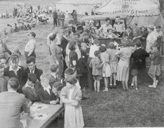
The Castlefields Carnival Show
on the field by the river c1951
Sydney Avenue may or may not take its (possibly misspelt) name from Sir Philip Sidney, soldier, poet and courtier (died 1586) who attended Shrewsbury School as a boy. It is lined with lime trees in the same manner as those in the Quarry – no doubt the design of Shrewsbury Horticultural Society’s head gardener, Percy Thrower, who also, rather over enthusiastically, set out the trees including some fruit trees on the island. A local man can remember ‘scrumping’ damsons and walnuts on the island and being chased off by large dogs. Gough’s Island, also known as France Island on some maps, was probably man-made by digging out an additional channel for the river to create fishing opportunities using nets. The island is privately owned and is connected to the bank on the far side by a bridge that has been replaced on more than one occasion.
Originally it was part of St Winefride’s on Underdale Road but was sold along with a plot of land on which a new house was built. The owners briefly kept alpacas on the island. Local legend has it that the Beatles, having performed at the Music Hall in 1962 or 1963, attended a party on the island.
RECORDING 5
The recreation land to the right was used as a general play area and was where the Castlefields Carnival Show was held for many years. This ceased in the 1950s allegedly ‘killed by the Entertainment Tax’!
Carry on along Sydney Avenue and at the weir bear right towards Burton Street. You will pass the old Vicarage on your left and Burton House on your right…
Burton Street first appears in 1871, named after Robert Burton, a banker of Princess Street who became a burgess of Shrewsbury in 1829 and was a member of the Burton family of Longnor. Burton House has a pump over a spring in its cellar. Note the lovely little summer house in corner of the wall of the Vicarage on your left, behind the public conveniences.
At the start of Burton Street turn right into Queen Street. Go along Queen Street, past the former All Saints (Church) Hall and the turning into North Street and just before the turning into New Park Street on your left turn right down a narrow road/alley between the houses to take you down to…
The Pleasure – sport, games, fun and shelters
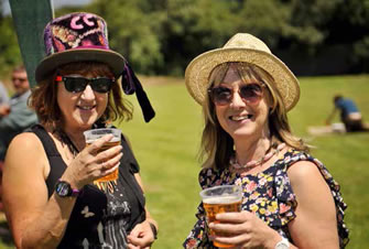
Castlefields Pleasure Day
Where other areas have a ‘rec’, Castlefields has ‘The Pleasure’. It was so charmingly called because it was not for farming or horticultural land, nor was it used for business – it was for pleasurable use. Local activists, many associated with All Saints Church, helped to create two bowling greens and two, if not three, grass tennis courts. The Bowling Club is thriving and to its credit has always worked hard to engage with young people, some of whom could easily have drifted into ‘trouble making’ activities. The grassy field part of The Pleasure used to have a pair of swings and one of those tubular climbing frame cubes that were once everywhere and are now seldom seen. In the early 2000s the current multi-purpose games area (MUGA) was installed. Older people can remember when there were underground air raid shelters on the Pleasure which were quite regularly used during the war.
Every summer since around 2005 there has been a Pleasure Day – a true community event designed not to make money for this or that charity but simply to bring people together to share games, food, music, entertainment and of course a drink or two.
RECORDING 6
Retrace your steps back on to Queen Street and turn right and walk on to where the road bends round to your left into John Street. On your right you will see…
The Allotments – growing things for necessity and pleasure
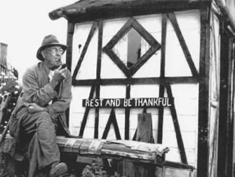
Jack Rowley and his allotment shed
The allotments originally extended well beyond the current site and covered much of now built-up area of Avondale Drive and Tilbrook Drive. The annual show was a popular community event and people like Jack Rowley took great pride in their sheds. It seems that some allotment holders kept pigs and chickens on their plots, which butted up against Prospect Cottage – a smallholding off the end of what is now Argyll Street. In the early 1800s much of the land on and below what is now Victoria Street was used for allotments or more accurately ‘detached gardens’ for people who lived in town within the ‘loop’ where land was at a premium. A detailed study of these allotments can be found at http://etheses.bham.ac.uk/3060/1/Thornes11PhD.pdf To your left there are two fairly recent houses that are set back across the corner. In a workshop at the rear of one of these, Dorothy and Alan Reynolds made sweets and lollipops which they sold from their door and also in the market in town. Alan, a Grenadier Guardsman, had been blinded in a bayonet charge during WWII.
RECORDING 7

Dorothy and Alan Reynolds – sweet makers
Follow John Street down to where it joins New Park Road – the Gospel Church (formerly Gospel Hall) is on the corner. Turn left and almost immediately left again and then right into Victoria Terrace. At the end turn right to find the Telegraph pub and…
The Community Hall – community life and housing
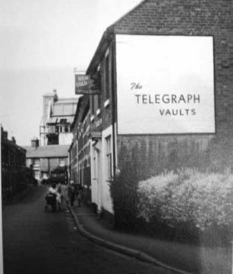
The Telegraph Vaults – The Gasworks are in the background
New Park Street originally extended right up to New Park Road. The demolition work and subsequent development of the shopping precinct in the 1970s included the construction of the well-used Castlefields Community Hall and the SPAR shop. During the late 1990s/early 2000s the precinct almost became a ‘no-go’ area due to antisocial behaviour often involving footballs. The Castlefields Action Team worked with Severnside Housing to ‘design out’ anti-social behaviour by relocating the flower beds and closing off one of the entrance/exits. Local volunteers planted and now maintain the flourishing flower beds. Every year Severnside Housing provides a Christmas tree with lights powered from the Community Hall.
The Telegraph was a survivor of the clearances. Like the Dog and Pheasant it is an active community pub and has reputedly got the longest bar in the town. In the 50s ‘Jockey’, the landlord, would organise ‘mystery bus outings’ – which usually went to Rhyl!
RECORDING 8
Carry on past the Community Hall towards the pedestrian precinct. On your left is the Spar and a little further on, the Friendly Neighbours base, the Cybercafe and two hair and beauty salons. Originally there was a butcher’s and a greengrocer’s, which also sold balls of wool. Turn left at the Spar to bring you back into the car park area with a recycling area on the far side.
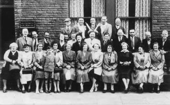
A mystery outing from the Telegraph Vaults